<-Frontpage
Research activities
Adaptive GIS
Adaptive GIS, situated at the crossroad of both Human-computer interaction, software adaptivity and geographical information systems, is a booming field of research. By integrating recent contribution in those domains, we derive GIS content and interface according to a given context and suited to users needs. Within an adaptive GIS, geographical data should be presented to the user with a specific attention to her/his characteristics, and the current context.
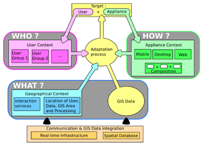
An adaptive GIS considers 3 sources of "knowledge" allowing the derivation of a context at the execution time:
- The geographical context identifies to which degree GIS services are available according to the user location and the spatial distribution of the services available.
- The appliance context specifies the interaction interfaces of the computing system available to a given user. These interfaces allow the user to visualize and interact with GIS data. Appliances are organized into classes of similar capabilities.
- The user context categorizes the users sharing a similar geographical context situation into a same group. With respect to a given service, the user context helps to qualify the adaptation process based on common behaviors within a group.
Contextual dimensions answers the questions "What to display ?" , "Who is the user ?", "How is data accessed ?" and feeds adaptation process with rules that constraint the geographical content and the way it is presented to the user (through the user-interface). Both dimensions integrates within an unified framework, providing generic guidelines to achieve the design of such adaptive and distributed GIS
For an in deft look at the sketch components, you might be interested in the following publications:
You froggies may be interested in the yearly report of my journey towards the Thesis definition (in French):
Lastest update: September 08, 2011